Chapter Contents
Remote sensing with drones is popular nowadays, particularly for very high spatial resolution image applications covering a relatively smaller area. This chapter will cover pre-flight preparation, drone flight, and post-processing for orthophotos and digital surface models.
Pre-flight Preparation
Drones
There are two types of drones depending on wing shapes – rotary wing type (Figure 1) and fixed wing type. Their characteristics can be summarized as follows:
|
|
Rotary Wing Type |
Fixed Wing Type |
|
Stationary Inspection |
Yes |
No |
|
Mechanical/Electrical Complexity |
High |
Low |
|
Payloads |
Less |
More |
|
Flying Speed |
Low |
High |
|
Large Area Survey |
More time consuming |
Less time consuming |
|
Take Off and Landing |
Vertical |
Requires Runway |
|
Inspection Applications |
Good |
Not good |
|
System Structure |
Helicopter, tricopter, quadcopter, hexacopter and octacopter |
Rigid wing with propeller |
|
Mapping Applications |
Good for smaller study area |
Good for larger study areas |
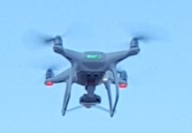
Figure 1. A rotary wing drone.
Regulations and Checklists
Drone imaging requires drone pilots to be familiar with various federal regulations about unmanned aircraft systems (UAS) that are found at https://www.faa.gov/uas/ (last visit on October 11, 2020).
In 2019, Dr. Sharma and Mr. Duran developed a checklist for small UAS flight operations (https://gaview.org/atlas/sUASchecklists.pdf). The following are DON’Ts and Do’s for pre-flight drone setup:
DON’Ts:
· Do not power on the drone before you power on the controller, the drone could fly away with no way to bring it back if the controller does not connect.
· Do not fly the drone without checking weather conditions (rain, humid, high winds, etc.)
· Do not turn off the controller while flying the drone.
· Do not fly without properly checking that the drone is in good working order.
· Do not fly if there are any GPS or electrical problems that prevents the drone from functioning smoothly.
· Do not fly on low battery no matter how far the distance.
· Don’t power up the battery without being attached to the drone.
DO’s:
· Be sure to have all equipment needed for the intended flight, this includes batteries, controllers, cameras, generators, etc.
· Check the weather and report to Air Traffic Control or airport if needed; this is in the case you are within 5 miles of an airport
· Have a flat surface for takeoff, free of debris and other obstacles.
· Always perform a preflight inspection of the drone, the engines, battery power, and all equipment attached to ensure a safe flight.
· Place the props on the drone and ensure they are ready for flight.
· Always turn on the controller prior to powering up the drone, this will ensure that the drone does not take off by itself with no control.
· Perform all compass, and sensor calibrations to prepare for flight.
· Create an appropriate flight plan that follows all FAA guidelines, and is safe for the public surroundings.
· Do keep accurate logs for every flight which includes flying time, location/study area, sensor and flight characteristics. Have a separate log for battery usage
Ground Control Points (GCPs)
GCPs need to be prepared before drone flight. GCPs improve the accuracy of post-processing of drone images. Existing targets such as distinctive marks on roads or parking lots may be used as good GCPs. If surveying is performed in the fields with limited good targets, then new GCP targets may be installed, for example, as shown in Figure 2. GCP locations are frequently surveyed with GPS equipment to obtain accurate horizontal and vertical coordinates on a geographic coordinate reference system. There should be enough GCPs to process drone photos, and they also need to be spread evenly across the entire study area.
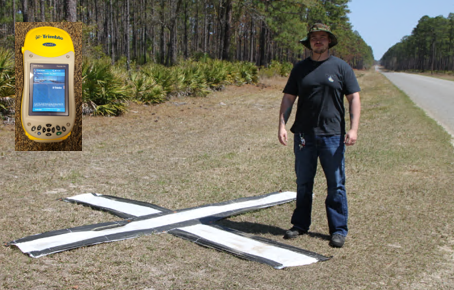
Figure 2. A ground control point that was set up in the Okefenokee Swamp area in March 2010.
Flying a Drone
Operational Limitations
The FAA (Federal Aviation Administration) limits drone operation as follows (https://www.faa.gov/uas/media/Part_107_Summary.pdf):
· Unmanned aircraft must weigh less than 55 lbs. (25 kg).
· Visual line-of-sight (VLOS) only; the unmanned aircraft must remain within VLOS of the remote pilot in command and the person manipulating the flight controls of the small UAS. Alternatively, the unmanned aircraft must remain within VLOS of the visual observer.
· At all times the small unmanned aircraft must remain close enough to the remote pilot in command and the person manipulating the flight controls of the small UAS for those people to be capable of seeing the aircraft with vision unaided by any device other than corrective lenses.
· Small unmanned aircraft may not operate over any persons not directly participating in the operation, not under a covered structure, and not inside a covered stationary vehicle.
· Daylight-only operations, or civil twilight (30 minutes before official sunrise to 30 minutes after official sunset, local time) with appropriate anti-collision lighting.
· Must yield right of way to other aircraft.
· May use visual observer (VO) but not required.
· First-person view camera cannot satisfy “see-and-avoid” requirement but can be used as long as requirement is satisfied in other ways.
· Maximum groundspeed of 100 mph (87 knots).
· Maximum altitude of 400 feet above ground level (AGL) or, if higher than 400 feet AGL, remain within 400 feet of a structure.
· Minimum weather visibility of 3 miles from control station.
· Operations in Class B, C, D and E airspace are allowed with the required ATC permission.
· Operations in Class G airspace are allowed without ATC
· permission.
· No person may act as a remote pilot in command or VO for more than one unmanned aircraft operation at one time.
· No operations from a moving aircraft.
· No operations from a moving vehicle unless the operation is over a sparsely populated area.
· No careless or reckless operations.
· No carriage of hazardous materials.
· Requires preflight inspection by the remote pilot in command.
· A person may not operate a small unmanned aircraft if he or she knows or has reason to know of any physical or mental condition that would interfere with the safe operation of a small UAS.
· Foreign-registered small unmanned aircraft are allowed to operate under part 107 if they satisfy the requirements of part 375.
· External load operations are allowed if the object being carried by the unmanned aircraft is securely attached and does not adversely affect the flight characteristics or controllability of the aircraft.
· Transportation of property for compensation or hire allowed provided that:
o The aircraft, including its attached systems, payload and cargo weigh less than 55 pounds total;
o The flight is conducted within visual line of sight and not from a moving vehicle or aircraft; and
o The flight occurs wholly within the bounds of a State and does not involve transport between (1) Hawaii and another place in Hawaii through airspace outside Hawaii; (2) the District of Columbia and another place in the District of Columbia; or (3) a territory or possession of the United States and another place in the same territory or possession.
· Most of the restrictions discussed above are waivable if the applicant demonstrates that his or her operation can safely be conducted under the terms of a certificate of waiver.
Flight Types
Drones can be flown in two ways:
· Manual flight: Flight with manual controls
· Programmed flight: Flight with user-programmed flight lines
For the manual flight of rotary type drones, two controls (i.e. left and right) are frequently used as shown in Figure 3. Drone flyers should be careful about their drone’s orientation. Figure 3 will work when a drone’s battery faces its operator.
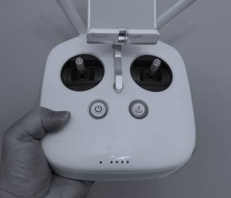
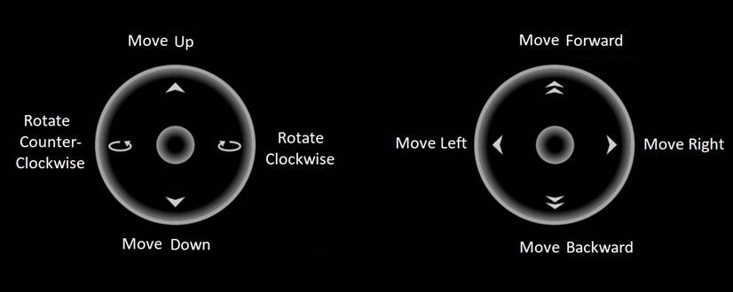
Figure 3. Manual drone flight with two controls.
Programmed flights use user-programmed flight lines. Many drone flight applications support user-programmed flights. Figure 4 shows different flight modes (i.e. missions) that can be programmed by users in the Pix4D Capture cellular phone app. Figure 5 is a cellular phone screen that shows an example of a grid mission, where white lines are flight lines, and the purple circles are the handles to resize the flight area.
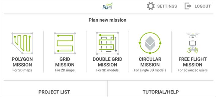
Figure 4. Programmable flight modes.
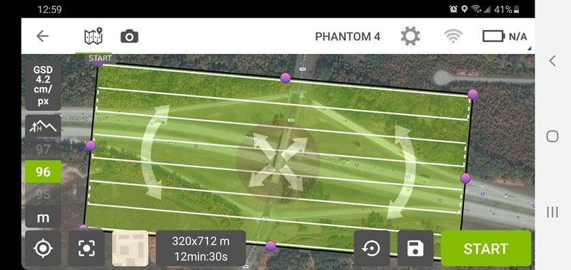
Figure 5. User-programmed flight lines.
Post-Processing Drone Images
Post-Processing
Individual drone images may deliver invaluable information. However, post-processing them may further allow users to derive invaluable secondary datasets. Some examples are orthophoto, digital surface model (DSM), point cloud, and 3-D model. Figure 6 shows the processing options available in the Pix4Dmapper software package. Post-processing outputs like orthophoto and DSM can be used with geographic information systems for further analysis.
Figure 6 shows an orthophoto overlayed on top of an outdated basemap. In the image the black-colored part indicates the void margins of the orthophoto, and the yellow circle markers are ground control points. Figure 7 shows the DSM of the same area of which elevation ranges from 250.3 m to 280.543 m. The tall tree patch at the lower left corner appears in red, and buildings and other trees contrast clearly against the bluish background. Both orthophoto and DSM have a spatial resolution of about 3.0 cm, which is very high for geospatial applications.
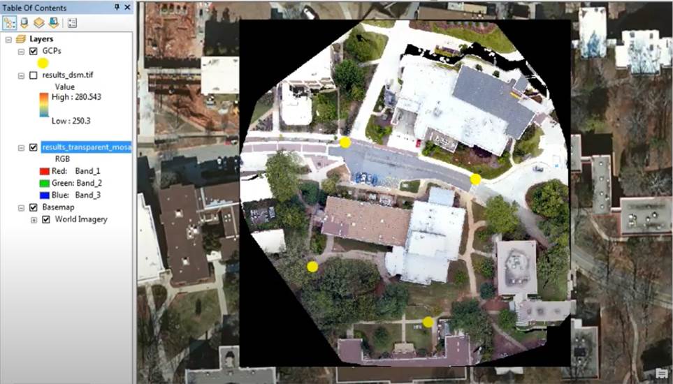
Figure 6. An orthophoto generated from eighteen photos taken from a drone at University of West Georgia in Carrollton, GA in 2017.
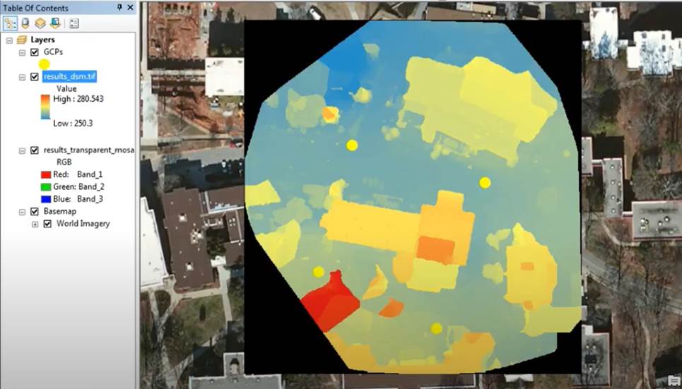
Figure 7. A digital surface model generated from eighteen photos taken from a drone at University of West Georgia in Carrollton, GA in 2017.
Post-Processing Tools
Post-processing of drone images requires an image processing software package. There are multiple drone image processing software packages. Examples of drone image processing software packages, as of October 2020, includes, but not limited to:
· Pix4Dmapper
· DroneDeploy
· AutoDesk ReCap
· SimActive Correlator3D
· Maps Made Easy
· 3DF Zephyr
· Agisoft PhotoScan
· PrecisionHawk
· Open Drone Map
· ESRI ArcGIS Drone2Map
· ERDAS Imagine
· ENVI
Application Fields
Remote sensing with drones can be very effective in various application fields because of fast and accurate data acquisition with relatively low operation cost. Drone application fields include, but not limited to:
· Surveying and mapping
· Inspection of structures or objects
· Mining and quarrying
· Precision agriculture
· Archaeology and documentation
· Cultural heritage preservation
· Game and video background modeling