Remote Sensing Application Fields
Introduction
Remote sensing has been a key component in the geospatial technology field. In this module, we will review various topics about remote sensing such as definition, history, components, applications, and careers in this chapter. The following example may give you an idea about what remote sensing is.
An Example of Remote Sensing: Flood Assessment
By early August 2010, two weeks of devastating monsoon rains had transformed the landscape of Pakistan, pushing rivers over their banks, inundating villages, washing away bridges and roads, destroying crops, and killing livestock. By August 12, 2010, more than 1,600 people had perished, according to news reports, and the United Nations Office for the Coordination of Humanitarian Affairs (OCHA) estimated that more than 14 million people had been affected in some way. To the Moderate Resolution Imaging Spectroradiometer (MODIS) on NASA’s Terra satellite, the impact of Pakistan’s floods was most obvious along the major rivers. These images use a combination of infrared and visible light to increase the contrast between water and land. Water appears in varying shades of blue, and clouds appear in varying shades of blue-green. Vegetation is green, and the bare ground is pinkish brown. Figure 1 shows before flooding (July 10, 2010), and Figure 2 shows during flooding (August 11, 2010). Figure 3 shows a flood assessment map created by UNOSAT in United Nations Institute for Training and Research (UNITAR).
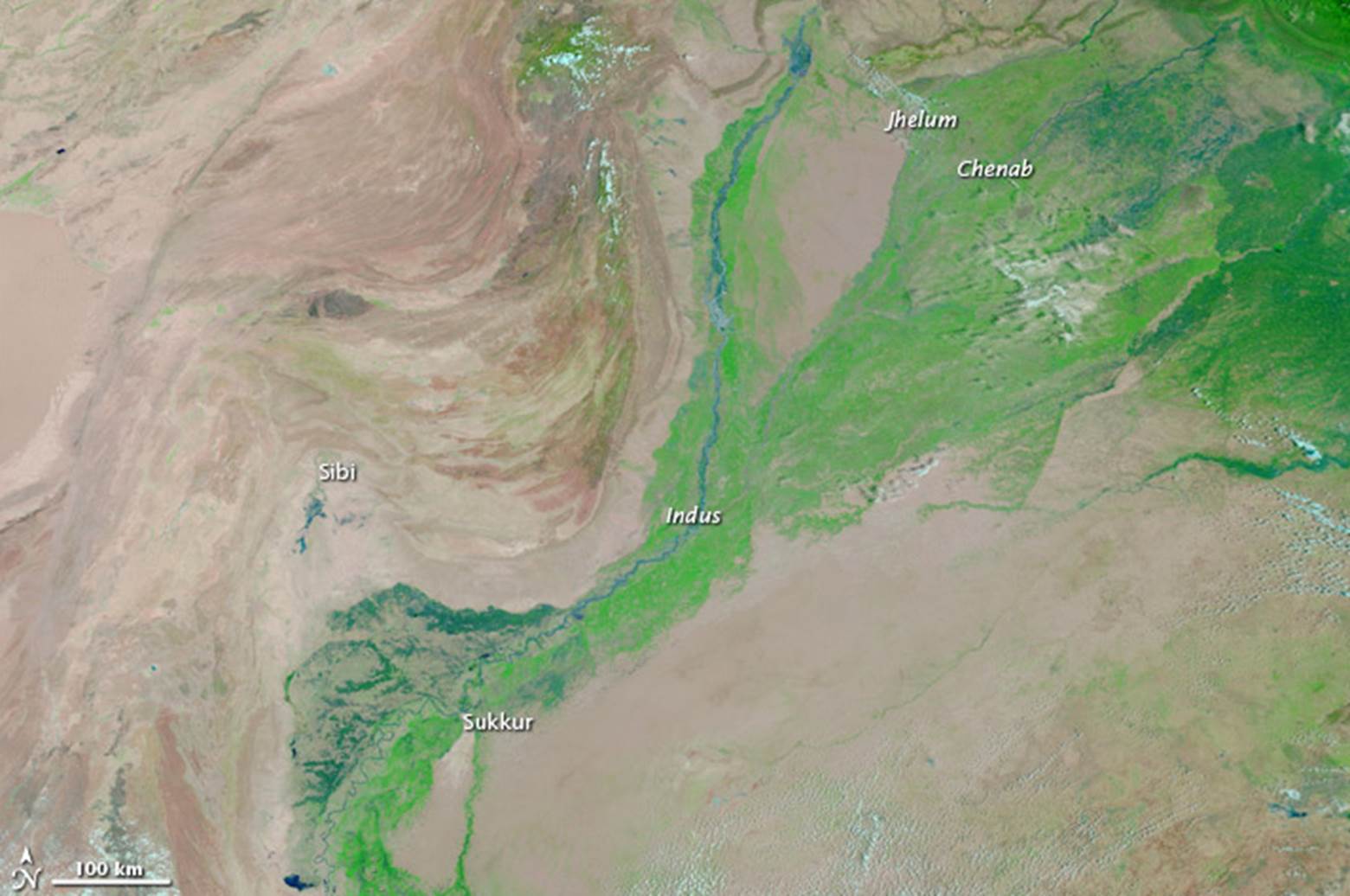
Figure 1. Before flooding. MODIS image on July 10, 2020.
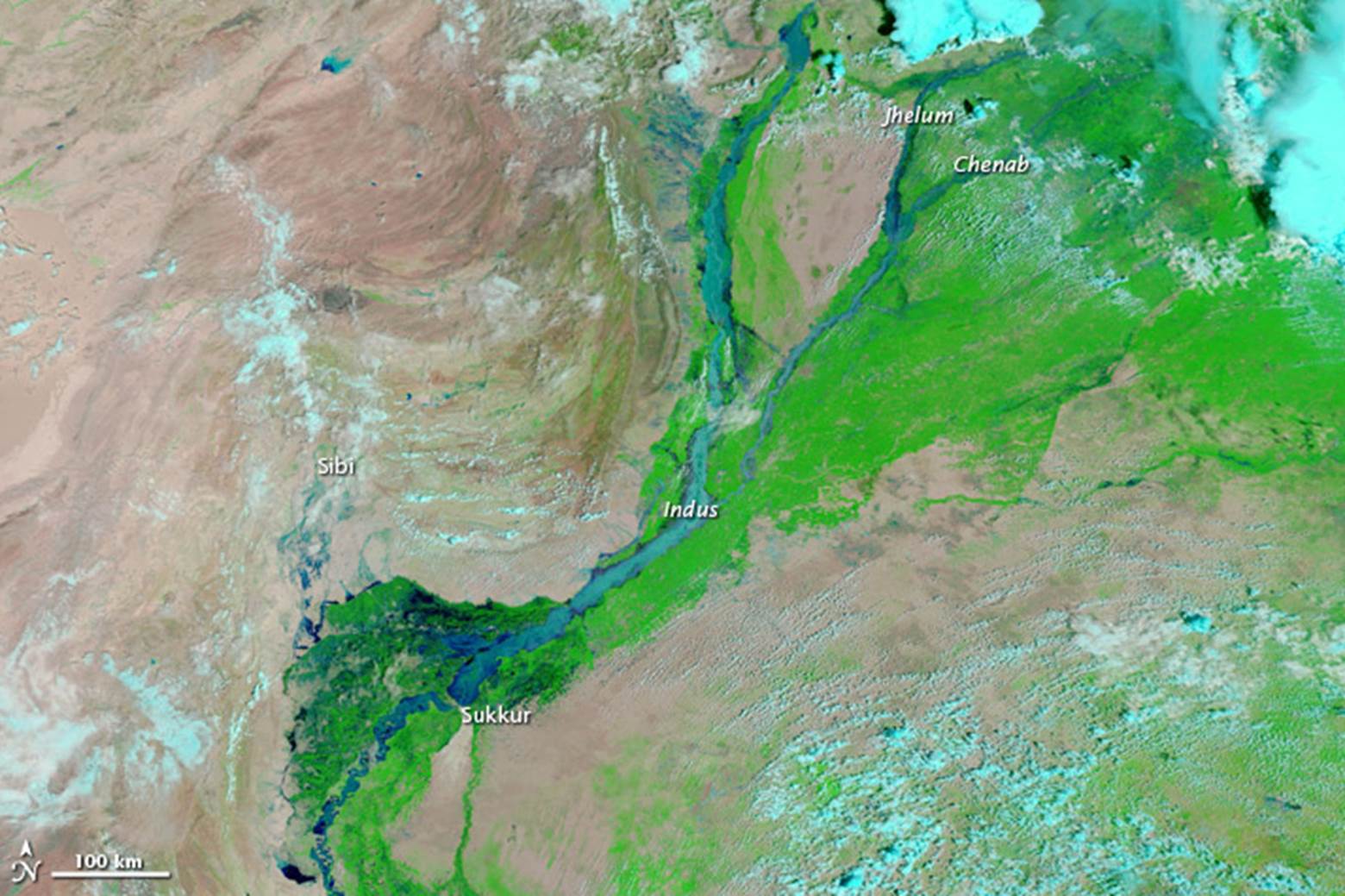
Figure 2. After flooding. MODIS Image on August 11, 2010.
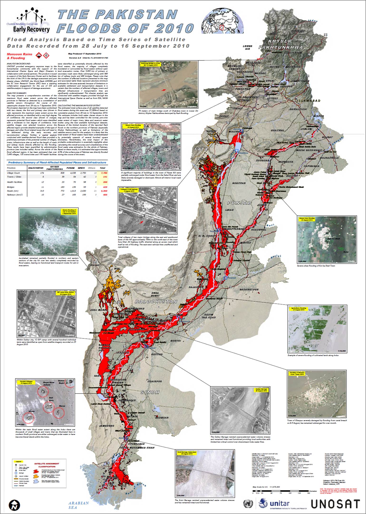
Figure 3. Flood assessment map created from remote sensing data. (ReliefWeb, 2010)
Even though many scientists define remote sensing differently, there exists one common factor. It is ‘obtaining information, about objects, without physical contact.’ Dr. Jensen, for example, defined remote sensing in his book (Jensen, 2010) as “The art and science of obtaining information about an object without being in direct physical contact with the object.” A similar definition appears in Lillesand and Kiefer’s book (Lillesand and Kiefer, 2000). According to them remote sensing is the science and art of obtaining information about an object, area, or phenomenon, through the analysis of data acquired by a device that is not in contact with the object, area, or phenomenon under investigation. Remote sensing is a science field because its foundation is scientific principles and theories and because remote sensing pursues scientific advancements. It is also regarded as an art because it asks creativity, particularly when image interpretation and visualization are involved.
Remote Sensing: A Key Component of Geospatial Technology
Geospatial technologies have recently grown significantly. Job opportunities are growing and diversifying as they prove their value in ever more areas. In 2004, the US Department of Labor identified geotechnology as one of the three most important emerging and evolving fields, along with nanotechnology and biotechnology (Gewin, 2004).
Recent development of geospatial technology fields can be characterized by four major components:
· geographic information systems (GIS),
· remote sensing (RS),
· global navigation satellite system (GNSS), and
· light detection and ranging (LiDAR).
Remote sensing contributes to the geospatial technology fields significantly by providing information-rich and timely data.
For example, most counties in the U.S. acquire remotely sensed airphoto as a backdrop of GIS system as shown in Figure 4. The image shows very detailed information.
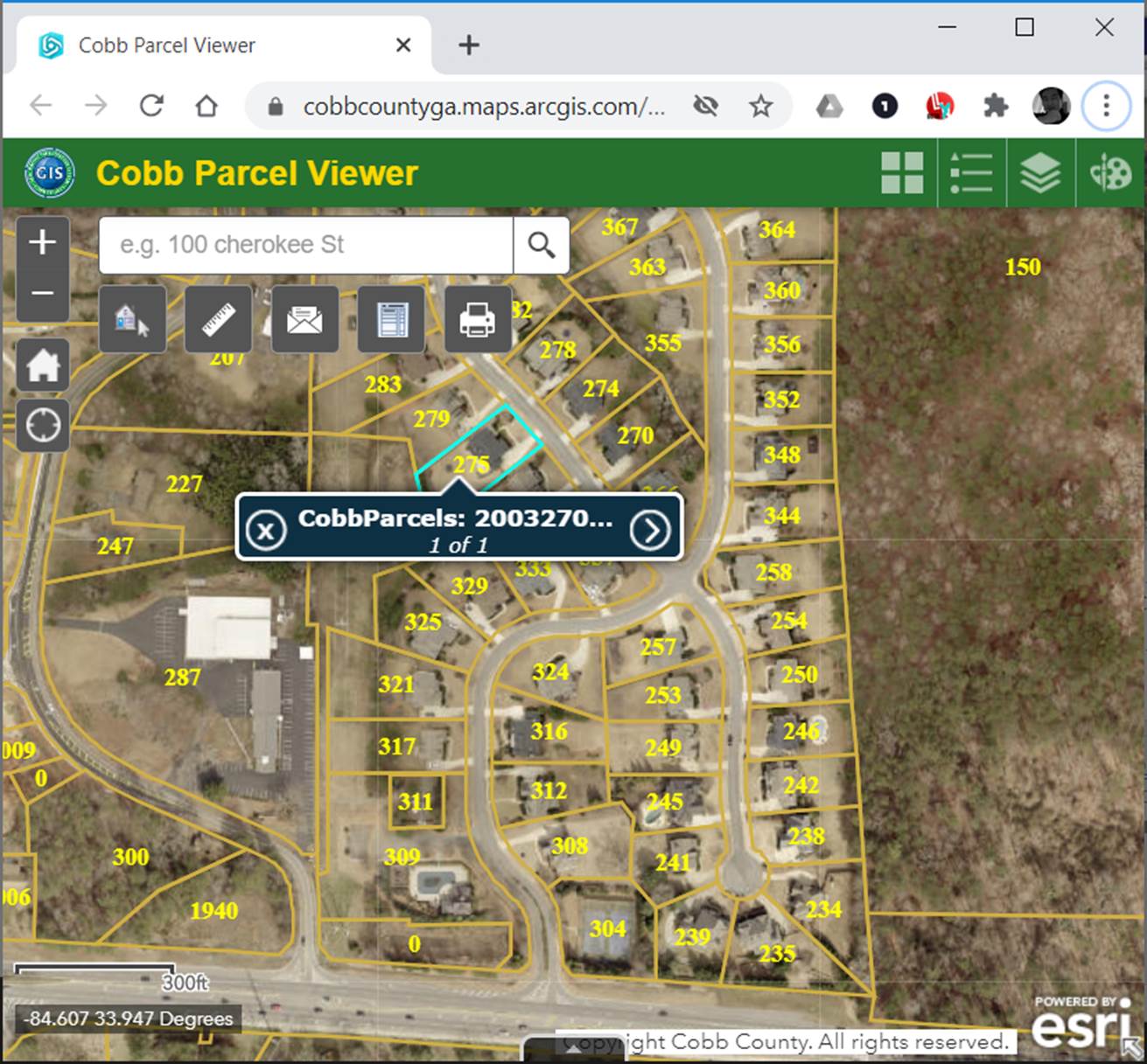
Figure 4. Airphoto used as a background of GIS in Cobb County, Georgia. (Cobb County, 2020)
Google Earth Pro and Google Map are also examples showing how remote sensing reshapes the mapping field. Map users, nowadays, enjoy high-resolution, aerial, and satellite imagery from the Web, covering the entire earth as an example in Figure 5. Integrated with GIS, GPS, and surveying, remote sensing provides invaluable opportunities to scientists, policy makers, researchers, businessmen, educators, the military, and the public.
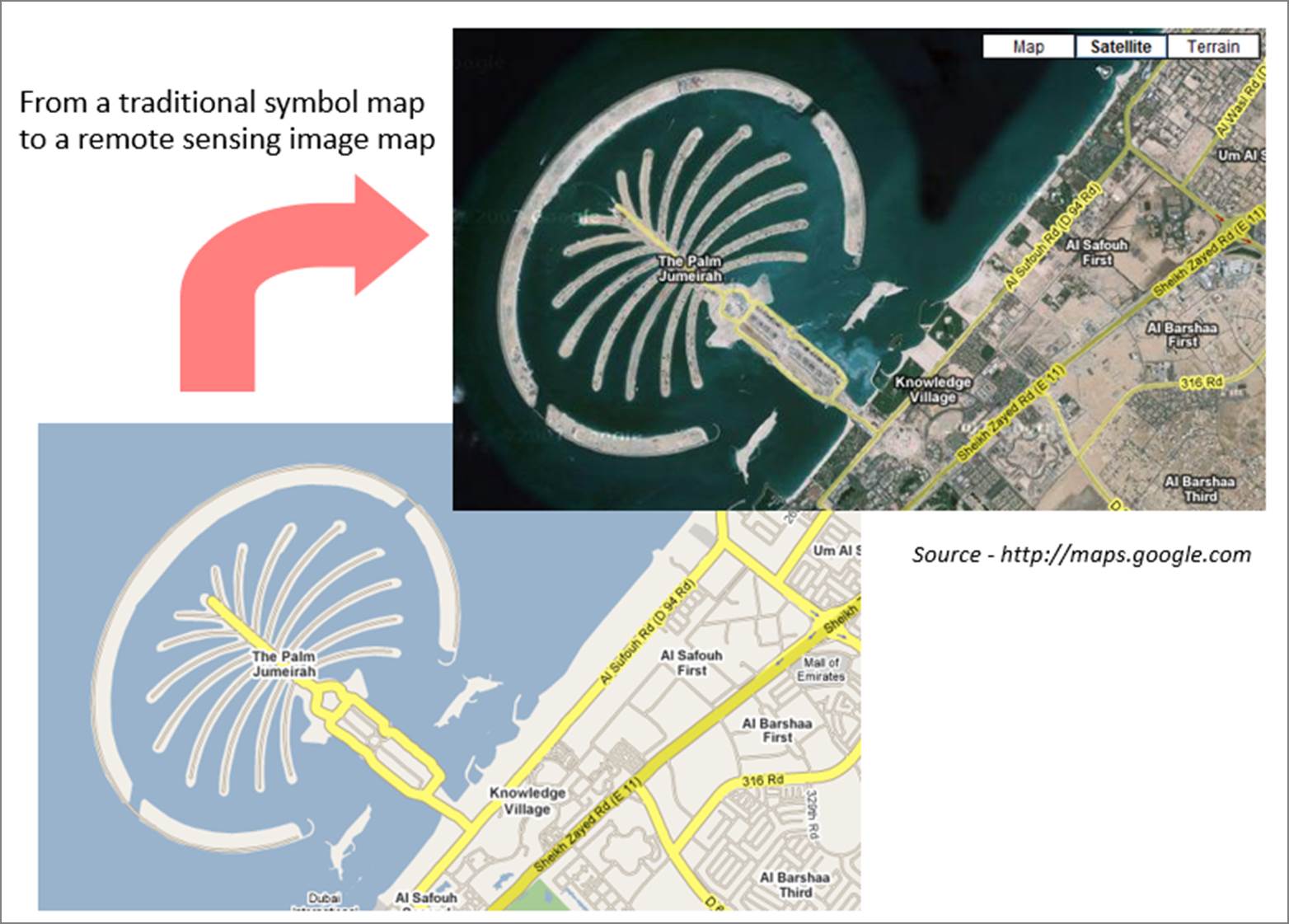
Figure 5. This figure shows how remote sensing transformed the mapping science field. With a high-resolution image as a background, the Google Maps reveals details of the massive engineering project in Dubai.
Figure 6 shows an example that remote sensing delivers timely information. Crude oil from the wrecked 146,000-ton tanker, Hebei Spirit, is seen polluting the sea off South Korea in this Envisat image. More than 10,000 tons of oil from the tanker was reported to have leaked into the sea after the ship collided with another vessel on Friday, December 7, 2007. The image map allows users to pinpoint oil-contaminated coastlines and water bodies with the radar image.
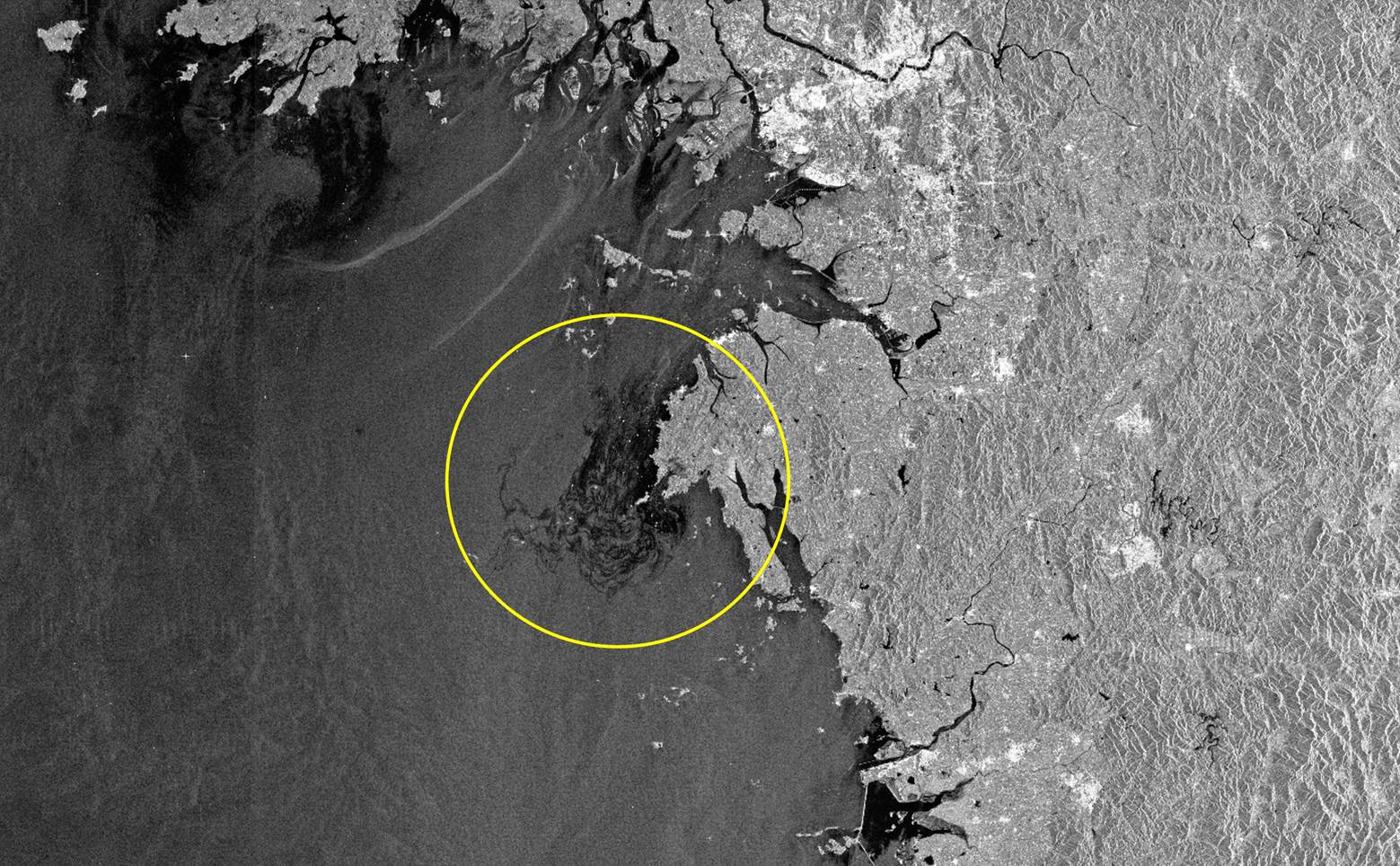
Figure 6. Oil spill in dark tones inside the yellow circle off South Korea. Image date: 12/11/2007. (NASA, 2007)
History of Remote Sensing
Remote sensing deals with the art and science of observing and measuring items on the Earth’s surface from a distance. The term, “remote sensing,” was first introduced in 1960 by Evelyn L. Pruitt of the U.S. Office of Naval Research. However, the first aerial photograph was taken in 1858, 102 years before the term “remote sensing” came into existence. Long before satellites and microcomputers started dominating the field of remote sensing, people were taking pictures of the Earth’s surface from afar. Taking these pictures was not an easy task and people risked their lives to bring about the development of the field.
The early development of remote sensing was strongly tied with the development of camera, film and aerial photography platforms.
The first primitive form of the camera was invented around the 16th century. It had pin-holes on a box-shaped camera obscura, which means, “dark room” in Latin. The camera obscura was widely used by artists. However, the technique of recording images on a film was not invented until the early 19th century.
In 1826, the first permanent photograph was made by a French inventor, Joseph Niépce. Niépce and Louis Daguerre refined this process. Especially, Daguerre discovered that exposing the silver in the film first to iodine vapor, before exposure to light, and then to mercury fumes after the photograph was taken, could form a latent image; bathing the plate in a salt bath then fixes the image. These ideas led to the famous daguerreotype.
Since then, various films have been developed including black and white, color, and infrared. The recent digital revolution also brought significant changes in imaging technology. Digital cameras can record the energies of multiple bands, even beyond the visible bands. They take pictures of the ground using a rectangular CCD array, or a linear CCD array. The former is the image type digital camera, and the latter is the scanner type.
Platform development is also another important aspect of remote sensing history. Balloons and birds, specifically pigeons, were used before airplanes became popular. Nowadays, airplanes and satellites are major platforms for taking images. Recently, UAVs (unmanned aerial vehicles) are frequently used in the military as well as civilian applications.
Processing digital image data became popular following the launch of the first Landsat satellite in 1972. Before the graphic user interface was popular, most software packages used the command-line user interface. In the command-line user interface, data processing and display commands were typed in a command prompt window with various parameters. With the development of computer technologies, remote sensing software packages have adopted graphic user interfaces, and have extended their functionalities to the photogrammetry and geographic information system areas. Also found in the recent development of remote sensing software technologies is a tight integration with network and cloud processing technologies.
There are many companies and organizations that provide remote sensing software products. The following are some examples:
· ArcGIS (https://www.esri.com/en-us/home)
· ERDAS Imagine (https://www.hexagongeospatial.com/products/power-portfolio/erdas-imagine)
· ENVI (https://www.harrisgeospatial.com/Software-Technology/ENVI)
· QGIS (https://qgis.org): Opensource and free of charge.
· Pix4D (https://www.pix4d.com/)
Remote sensing also uses various hardware products. One tool unique for remote sensing is the stereoscope. Stereoscopes allow users to see objects in 3-D using two photos. They have been very popular in interpreting printed aerial photos. A stereoscope, as shown in Figure 7, is essentially an instrument in which two photographs of the same object, taken from slightly different angles, are simultaneously presented, one to each eye. Each picture is focused by a separate lens, and the two lenses are inclined to shift the images toward each other and thus ensure the visual blending of the two images into one three-dimensional image.
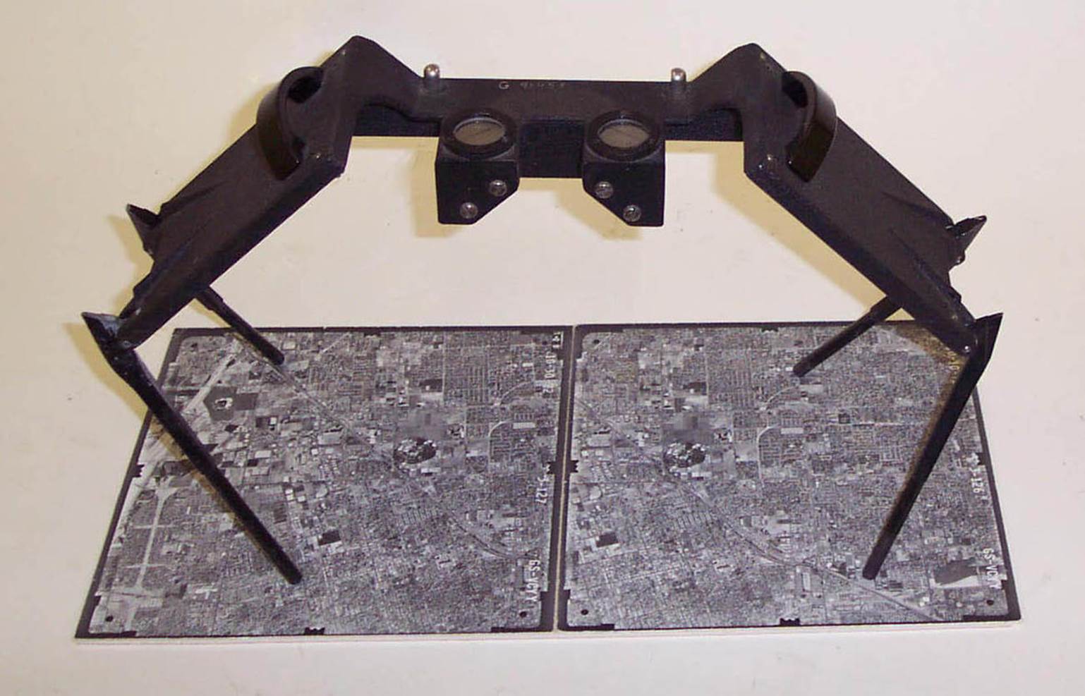
Figure 7. A stereoscope. (USGS, 2020)
Stereoplotter is an advanced form of stereoscopes. It allows users to trace contours, roads, and other features from a virtual three-dimensional model. Those points, lines, and polygons later forms the bases of maps. Figure 8 shows an example of a stereoplotter.

Figure 8. A mechanical (analog) stereoplotter. (NOAA, 2017)
Development of digital imaging and processing equipment has also contributed to the development of remote sensing techniques. Such equipment includes digital cameras, scanners, digital photogrammetric workstations, etc. Figure 9 shows an example of a digital stereoplotter.
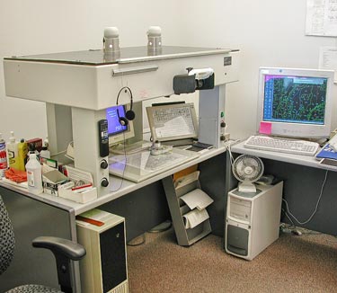
Figure 9. Digital stereoplotter. (USGS, 2004)
Remote Sensing System
To sense objects remotely, we need three essential components. They are targets, energy sources, and sensors. Targets are the objects or materials that are being studied. Energy sources illuminate or provide electromagnetic energy to targets. A sensor is also needed to collect and record electromagnetic radiation.
Sensors can be used to measure the energy that is emitted by a target, reflected off from a target, or transmitted through a target. Some sensors record incoming energy passively, and others actively transmit energy and record backscattered energy. The former is known as passive remote sensing while the latter is active remote sensing. Radar sensors are active remote sensing sensors, and most cameras are passive remote sensing sensors. Infrared thermometers also use passive sensors so that they detect thermal infrared energy radiated from objects.
There are three major subsystems in remote sensing. As shown in Figure 10, they are data collection, data manipulation, and interpretation and analysis systems. Platforms, sensors, and receiving stations are major components of the data collection system. The data manipulation system contains storage, processing, and retrieval functions. The interpretation and analysis system focuses on the creation of information from data using various interpretation and analysis techniques.
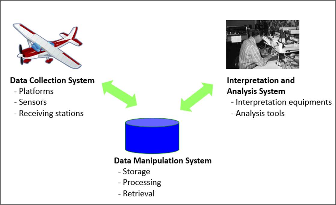
Figure 10. Three subsystems in remote sensing.
Remote Sensing Application Fields
Remote Sensing has been applied to a broad range of fields and organizations. This section will introduce them with four major categories – military, local governments, state and federal governments, and the private sector.
In the military area, remote sensing has been used for surveillance, combat support, target monitoring, and national security. Along with the development of UAVs, military remote sensing applications are growing rapidly.
Almost every local government also uses remote sensing products along with geographic information systems. It is quite common to see that images are used as the background of city and county maps. Remote sensing also helps local governments monitor illegal changes in man-made or natural features. Planning, environmental assessment, and engineering projects also benefit from using remote sensing products.
State and federal governments also use remote sensing for natural resources management, change monitoring, social infrastructure management, physical environment monitoring, transportation projects, and mapping projects. For example, Figure 11 shows monitoring wildfires near San Francisco on 8/19/2020.
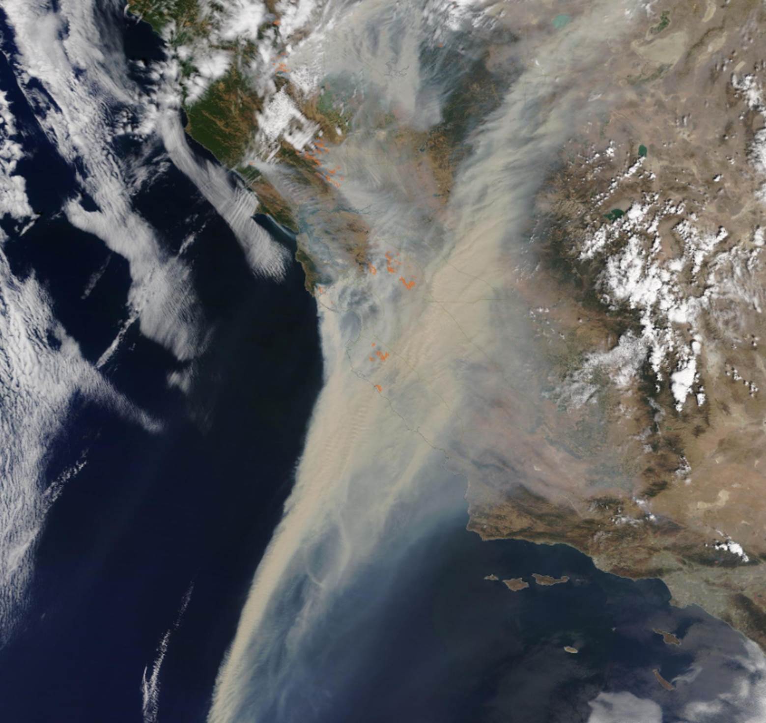
Figure 11. Wildfires near San Francisco on 8/19/2020. (NASA, 2020)
The private sector also uses remote sensing rigorously. Energy and electricity companies, for example, need images to monitor tree growth along power lines. Agriculture or forestry applications include real-time plant monitoring, soil moisture change monitoring, and forest harvest monitoring, to name a few. Engineering companies use remote sensing to support engineering projects. Mining and surveying industries frequently use remote sensing.
Careers in Remote Sensing
According to an article from ASPRS (American Society for Photogrammetry and Remote Sensing):
Ten or 20 years ago, "planning your life's career" meant just that. People tended to learn a relatively narrow set of skills and "settle in" to a professional life with a simple career path and one or two employers. Today, this traditional employment model still exists, but a current professional career might also involve multiple employment relationships, participation in a "virtual" organization, self-employment, or pursuit of many types of jobs during one's lifetime. The bottom line in today's world is that it pays to be educated broadly, yet skilled technically, to meet the challenges and reap the tremendous opportunities of an information-based global economy. More and more, this information-based global economy is becoming a geospatial information-based economy. Such tools as aerial and satellite remote sensing imagery, the Global Positioning System, and computerized geographic information systems are revolutionizing the conduct of business, science, and government alike. (Source: http://www.asprs.org/a/career/)
There are five major career fields (Figure 12) in remote sensing - services, hardware, software, data, and education. They are not exclusive, but rather, mixed.
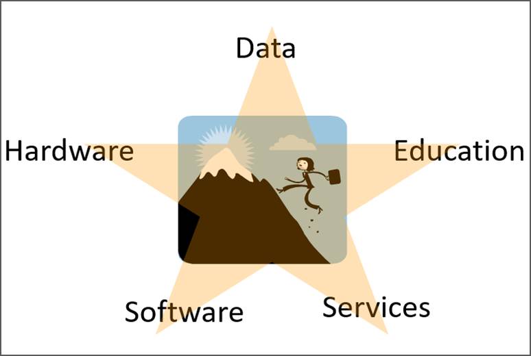
Figure 12. Five major career fields in remote sensing.
Searching jobs at the following websites with keywords like “remote sensing” or “GIS” will show remote sensing and geospatial jobs.
· https://www.usajobs.gov/ : Federal government jobs
References
Cobb County, 2020. https://www.cobbcounty.org/gis
Jensen, J.R., 2000. Remote Sensing of the Environment: An Earth Resource Perspective. Prentice Hall, Saddle River.
Lillesand, T.M. and Kiefer, R.W., 2000. Remote Sensing and Image Interpretation. John Wiley & Sons, New York.
NASA, 2007. https://visibleearth.nasa.gov/images/8304/oil-spill-off-south-korea/8305l
NASA, 2020. https://modis.gsfc.nasa.gov/gallery/individual.php?db_date=2020-08-21
NOAA, 2017. https://celebrating200years.noaa.gov/transformations/mapping/image9.html
ReliefWeb, 2010. https://reliefweb.int/map/pakistan/pakistan-floods-2010-flood-analysis-based-time-series-satellite-data-recorded-28-july
USGS, 2004. https://pubs.usgs.gov/of/2004/1451/brown/index.html
USGS, 2020. https://www.usgs.gov/media/images/stereoscope
Virginia Gewin, 2004. Mapping Opportunities. Nature, 427: 376-377. https://www.nature.com/articles/nj6972-376a.pdf
[Last Update: 8/27/2020]